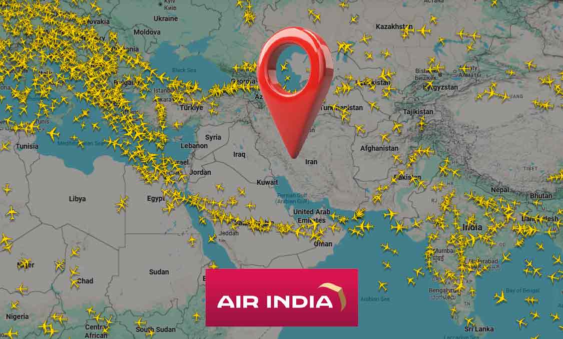
As the war in middle east against Iran continues, the airspace over Iran and other neighbouring countries has been closed for civilian aircraft. As the sky has become an aerial minefield with swarms of drones, missiles and fighter planes flying in the region, it is certainly not safe for air travel over the place. Amid this situation, a screenshot of a flight tracking site has gone viral on social media, claiming that an Air India flight flew over Iran.
The claim spread after screenshots from popular flight-tracking platform Flightradar24 began circulating widely, showing Air India Flight AI121 from Delhi to Frankfurt flying directly over central Iran on March 4. One viral post, shared by Instagram user @mrdadhiwalaofficial and shared by many users on X, captioned the image with a cheeky remark about Air India’s “aura”.
The screenshot with the lone Air India flight over empty Iranian airspace circled in red was shared by many users with comments like “Looks pilot had Mountain Dew”.
Air India Flight AI121 Spotted Over Central Iran Amid Congested Regional Airspace…
Looks pilot had Mountain Dew😎🤏🏻#India_Aura pic.twitter.com/ydD7H8Y2nr— 𓆩Hคरຮђ𓆪 (@Hello_Harshu) March 4, 2026
The screenshot is genuine, and it raises a concern about why Air India will choose to fly over restricted airspace, as Iran’s airspace has been partially or fully closed since late February 2026, following escalations in the Israel-Iran conflict that prompted emergency advisories from global aviation authorities. Several flights on the routes were forced to return or divert on February 28 after the war started.
However, the fact is that no passenger flight flew over Iran after the airspace was closed, and Air India has also clarified that the Delhi-Frankfurt flight on 4th March didn’t fly over Iran. In an official statement posted on X on March 5, the airline’s newsroom labelled the claims “Fake News,” asserting that “Air India does not operate flights over any restricted airspace.” Air India said that the claims circulating on social media are incorrect and do not reflect the carrier’s actual flight operations or safety protocols.
The statement added, “Flight routes are planned using real‑time intelligence, global advisories, and continuous monitoring to ensure every journey remains safe, compliant, and reliable. These operational decisions underline Air India’s firm commitment to prioritising the safety and security of passengers and crew above everything else.”
Fake News Alert – “Air India flew over restricted airspace in the Middle East despite tensions in the region.”
These claims circulating on social media are incorrect and do not reflect our actual flight operations or safety protocols.
Actual Information – Air India does not… pic.twitter.com/b8YTisS3SG
— Air India Newsroom (@AirIndia_News) March 5, 2026
Air India also posted an image showing the route taken by AI121 Frankfurt to Delhi flight, which shows that it flew over Saudi Arabia, Oman and the Arabian Sea, completely bypassing the warzone in and around Iran.
However, this does not mean that the screenshots shared on social media are wrong. This is because flight tracking websites like Flightradar24 are not able to show the correct position of the flight in and around the warzone.
Strong GPS interference in the region is affecting some flights. The erratic flight paths and perfect circles are signs of GPS spoofing. We try to mitigate the effects of spoofing when we are able: https://t.co/QIq6p3Z29h pic.twitter.com/VkHoj5SsTy
— Flightradar24 (@flightradar24) March 2, 2026
In fact, Flightradar24 had already addressed the issue on March 2, days before the AI121 screenshot went viral. They explained that strong GPS interference in the region is affecting some flights. This included erratic flight paths and perfect circles for some slight paths shown on its portal.
GPS spoofing is a wartime tactic where fake GPS satellite signals are transmitted to mislead navigation systems of enemies, causing the drones, missiles and fighter aircraft to lose their GPS navigation. The GPS spoofing does not block GPS signals, instead, fake signal with wrong location data is transmitted, tricking a device in a wrong location into believing that it is at the correct location. Fake GPS signals can be transmitted from fixed and mobile ground stations, ships, Electronic warfare aircraft, specialised drones etc.
As GPS spoofing is being deployed in the warzone in the Middle East, civilian aircraft flying in and around the region are also being affected. And as flight tracking portals like Flightradar24 use GPS data transmitted by the transponders of the aircraft, it is showing the wrong location and flight path for some flights in the region.
This is the reason why the Air India flight appeared to be flying over Iran. Several such irregular flight paths were seen on Flightradar24, showing the extensive impact of GPS spoofing. Mostly, flights over the UAE can be seen showing such unnatural paths, as its airports have resumed partial operations.
Flightradar24 added that they try to mitigate the effects of spoofing, and linked to a blog on how it uses multilateration (MLAT) technology, which cross-references ground receivers to correct distorted data.
Notably, pilots don’t depend on only GPS for navigation; they rely on inertial navigation and air traffic control radar as backups. Therefore, GPS spoofing does not pose an operational hazard; it only confuses people using GPS signals to track the flights.
It is important to note that the US military runs the Global Positioning System and allows its civilian use for free. But it uses encrypted military signals for military operations, which can’t be spoofed easily. This means that while the US can spoof GPS signals, its own missiles and drones are immune to it, as they use the secure, encrypted signals, which are also much more accurate than civilian signals. The US allows some of its partners to use the encrypted signals during military operations.
As the US can block access to GPS, several countries have developed their own satellite navigation systems. This includes Russia’s GLONASS, China’s BeiDou Navigation Satellite System, the European Union’s Galileo and India’s NavIC.